Army Upgrades Tactical ISR with Skydio X2D Drone Platform
Robot Details
Skydio X2D • SkydioPublished
January 23, 2026
Reading Time
2 min read
Author
Origin Of Bots Editorial Team

Army ISR Revamp
The U.S. Army is bolstering its tactical intelligence, surveillance, and reconnaissance capabilities by integrating the Skydio X2D drone platform into frontline operations. This upgrade addresses gaps in short-range reconnaissance, delivering NDAA-compliant, U.S.-made autonomy for contested environments. Built to exceed SRR program standards, the X2D enables soldiers to conduct real-time aerial scouting without relying on foreign tech, transforming how units gather battlefield intel amid rising global tensions.
Autonomy Edge Unveiled
Skydio's X2D stands out with its Skydio Autonomy Enterprise system, powering AI-driven flight that handles GPS-denied navigation and full-mission automation. Operators leverage a rugged controller featuring a 6.8-inch touchscreen and joysticks for control up to 10 km away, complete with AES-256 encryption for secure links. This setup lets teams focus on strategy rather than manual piloting, especially during night ops or in urban clutter where traditional drones falter.
Sensor Fusion Breakthrough
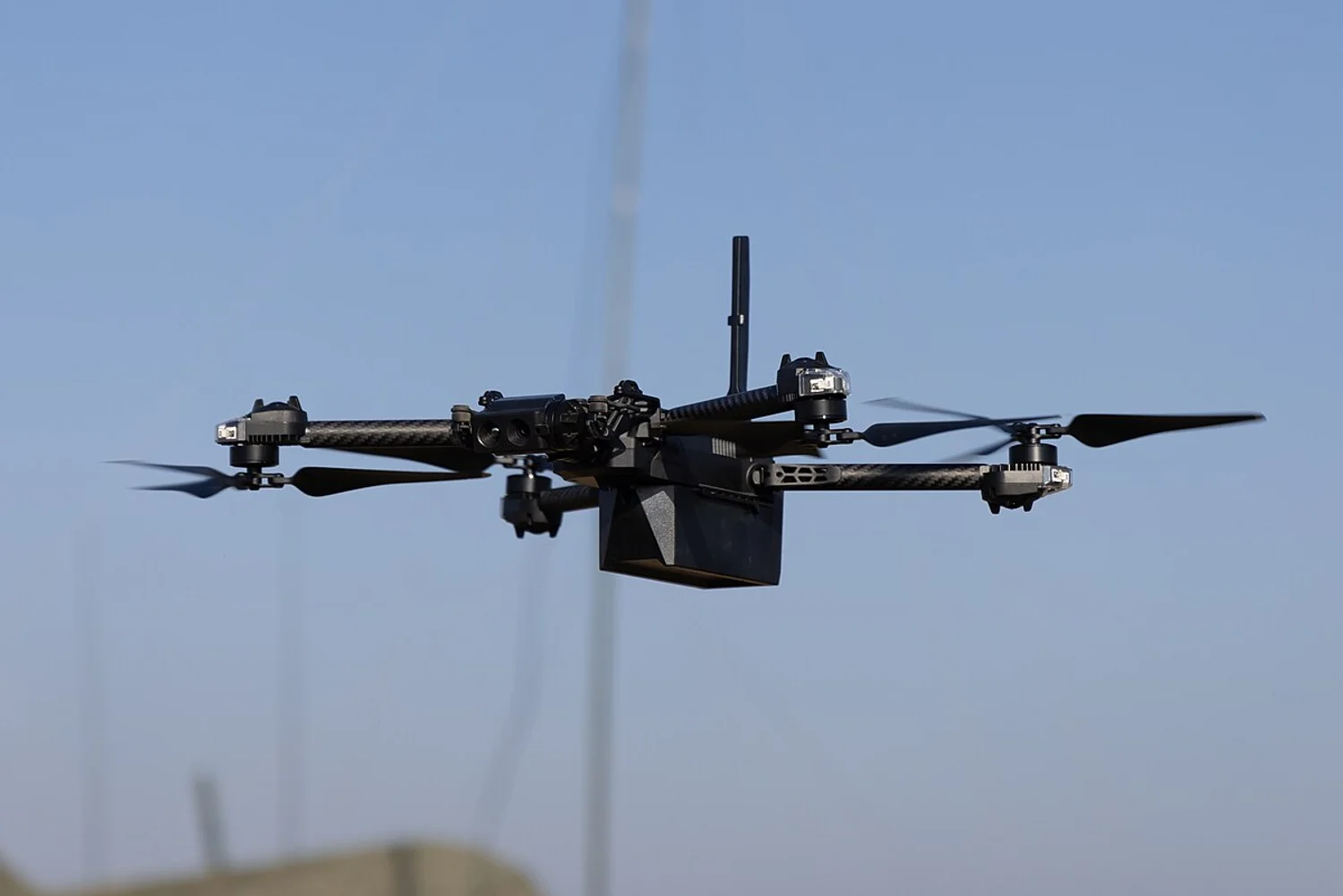
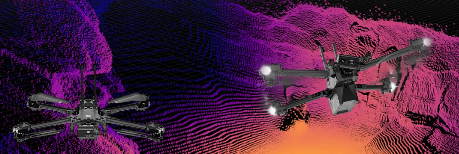
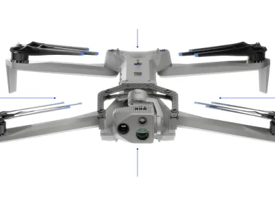
Engineering feats in the X2D include six 4K60P HDR navigation cameras for omnidirectional vision and a FLIR Boson 320 thermal imager on a 180-degree gimbal, enabling 360-degree obstacle avoidance via SLAM and visual odometry. Paired with GPS, barometer, and IMU sensors, it creates instant 3D maps for precise motion planning. These advances ensure reliable performance in winds up to 23 mph and temperatures from -10°C to 43°C, redefining drone resilience in harsh theaters.
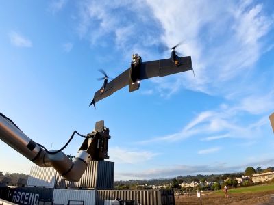
Battlefield Missions Transformed
Defense teams deploy the X2D for rapid battle damage assessments, triangulating targets with crosshair coordinates and DTED maps to pinpoint IEDs or enemy positions. Public safety and search-rescue crews use its thermal zoom for night extractions, while infrastructure inspectors map sites in 3D with optional Skydio 3D Scan. Foldable design packs into backpacks for instant launches, supporting 35-minute flights that cover critical windows in dynamic scenarios.
Specs Power Missions
Measuring 38 × 30 × 10 cm and weighing 1.3 kg, the quadrotor X2D hits 31 mph forward, 22 mph ascent, and 9 mph descent, ideal for quick tactical repositions. Its sensor suite—six 4K60P HDR cameras, FLIR thermal, and full IMU—drives 360° avoidance, cliff detection, and emergency protocols under weak GPS. Batteries last 2-3 years typically, with custom payloads up to 150 g on brushless motors, while Skydio OS delivers AI assistance for mapping in defense recon or security sweeps.
Rivals Edge Check
| Robot | Strengths over Skydio X2D | Skydio X2D Advantages | Weaknesses vs. Skydio X2D |
|---|---|---|---|
| Skydio F10 | Lighter build for stealth | Superior thermal gimbal, longer range | Less multiband freq flexibility |
| Skydio R10 | Newer AI updates | Proven SRR compliance, NDAA-ready | Slightly shorter endurance |
| DJI Avata 3 | FPV immersion, cheaper | Full 360° avoidance, U.S.-made security | Weaker in GPS-denied ops |
| DJI Neo 2 | Compact, beginner-friendly | Enterprise autonomy, 10km control | Higher weight limits payloads |

Related Articles
IZI Sky Pro 4K Drone Revolutionizes Aerial Imaging

DJI FlyCart 30 Revolutionizes Heavy-Duty Drone Delivery

DJI FlyCart 100 Revolutionizes Heavy-Lift Drone Delivery

DJI Mini 5 Pro Unleashes 1-Inch 50MP Sensor, 4K/120fps Power
Related Comparisons
Compare Skydio X2D with similar robots

Skydio X2D vs Skydio X10
Compare Skydio X2D vs Skydio X10 for camera quality, flight time, range, and cinematic capabilities in defense and inspection.
Skydio F10 vs Skydio X2D
Compare Skydio F10 vs Skydio X2D for camera quality, flight range, obstacle avoidance, and professional surveillance performance.

Skydio R10 vs Skydio X2D
Compare Skydio R10 vs Skydio X2D for low-light camera quality, indoor autonomy, range, and safety in public safety vs enterprise inspection.
Skydio F10 vs Skydio X10
Skydio F10 or Skydio X10? Compare for surveillance endurance, high-res cameras, thermal imaging, range, and professional inspection reliability.
Learn More About This Robot
Discover detailed specifications, reviews, and comparisons for Skydio X2D.
View Robot Details →